Sentier du Viala

Kaiser113
User
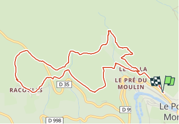

Length
6.8 km

Max alt
1132 m

Uphill gradient
275 m
Km-Effort
10.5 km

Min alt
892 m

Downhill gradient
283 m
Boucle
Yes
Creation date :
2022-10-25 19:56:40.987
Updated on :
2022-10-25 19:57:13.423
2h22
Difficulty : Medium

FREE GPS app for hiking
 SityTrail
IGN / Geographical institutes
SityTrail Plus
The world is yours!
About
Trail Walking of 6.8 km to be discovered at Occitania, Lozère, Pont de Montvert - Sud Mont Lozère. This trail is proposed by Kaiser113.
Positioning
Country:
France
Region :
Occitania
Department/Province :
Lozère
Municipality :
Pont de Montvert - Sud Mont Lozère
Location:
Fraissinet-de-Lozère
Start:(Dec)
Start:(UTM)
559029 ; 4912739 (31T) N.
Comments